01229 825085
Art Gene, Bath Street, Barrow-in-Furness,
Cumbria, LA14 5TY England, UK
01229 825085
Art Gene, Bath Street, Barrow-in-Furness,
Cumbria, LA14 5TY England, UK


Top image: The Seldom Seen™ Series of Maps, by Stuart Bastik, Art Gene, 2016
“ The Seldom Seen Series of Maps capture an extended conversation about the value and character of place. A conversation between hundreds of members of our community. Many of whom have never met”.
Stuart Bastik, 2016
Developed by Art Gene working closely with Morecambe Bay Partnership, together, these 5 maps span from the islands of Barrow to Cockerham; plotting the hidden assets of the spectacular Morecambe Bay area of Cumbria and Lancashire.
This series of illustrated maps details current and historic points of interest, including internationally significant nature reserves and places of more surprising ecological importance alongside sites of industrial endeavour – and key figures who have left their mark on the town and its islands.
By capturing each area’s remarkable natural history, industrial (and military) heritage and social history, the Seldom Seen™ Series of Maps reveals that places are never just one thing, but layers coexisting and connecting through time.
The Seldom Seen™ Series of Maps is available individually, or as a boxed edition of all 5, from Lancaster and Morecambe Visitors Information Centres.
Walney, Barrow, Foulney, Piel, Ramsey, Roa & Sheep Islands – Headin Haw & Dova Haw.
Featuring: Rigid Airships – Natterjack Toads – Gulls – Super-Normal Stimuli – Basking Sharks – X-Craft – Atlantic Seals – Submerged Forests – Cistercian Farms – Fort Walney – Barnes Wallace – Sand Dunes – Semaphore – Hermits – Howitzers – Searchlights – Slow Worms – Salt Works – Sandwich Terns – O shore Windfarms – Pipefish – Polaris – Practice Trenches – Hides – Oysters & Mass Observation…
“Barrow-in-Furness grew rapidly across the islands of Barrow, taking advantage of the natural harbours between them. By 1865, Barrow had established the largest ironworks in the world – much to the disapproval of Victorian social reformer John Ruskin, who could see it lighting up the night sky from his home 20 miles away”.
Extract from the cover text of the Islands of Barrow map
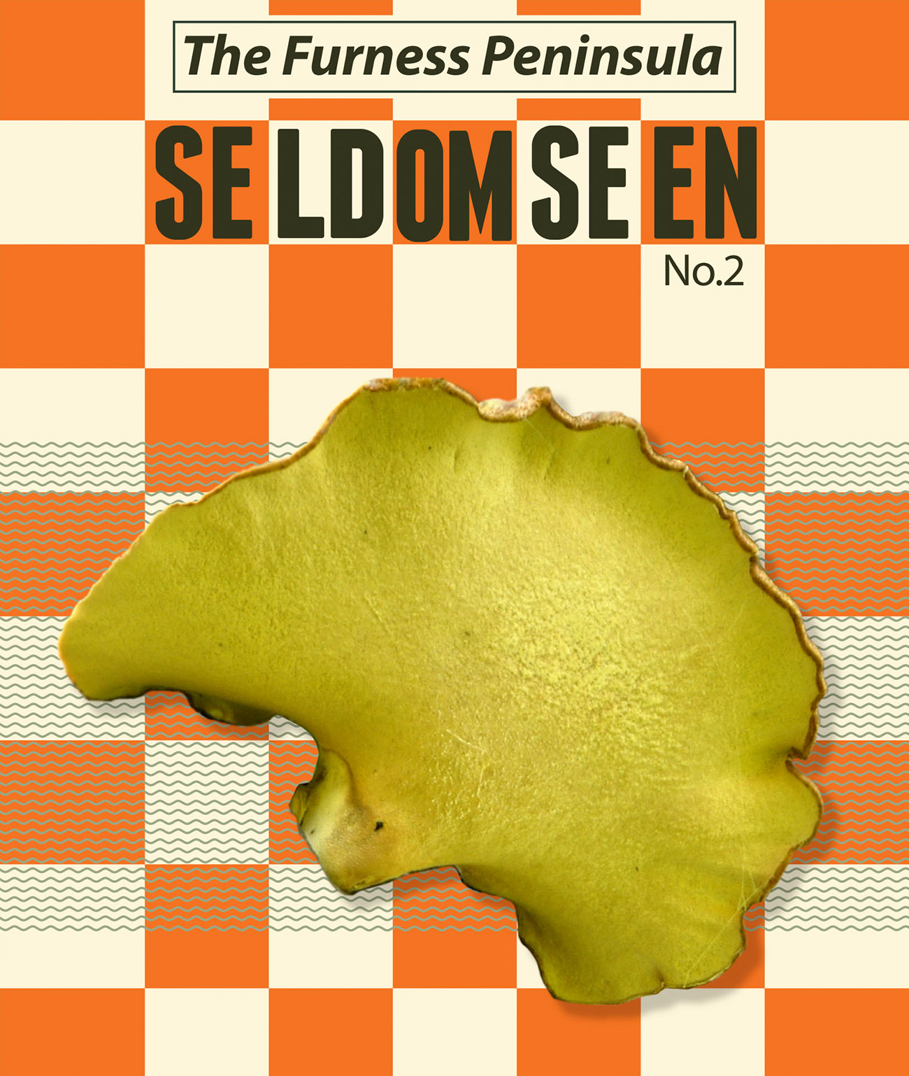
Furness Peninsula
Barrow-in-Furness, Dalton-in-Furness, Newton, Askam-in-Furness, Ulverston, Millom, Gleasdon, Scales, Aldingham, Bardsea, Urswick & Stank.
Featuring: Cut-marked Human Bones – Nuclear Submarines – Quakerism – Castles – Trains falling into mines – Tigers – Antiquarians – The earliest Book Club in the World – The Fat Controller – Lizards-AVikingHoard- StanLaurel-TheManorofMuchland- Lost Villages – Devils Bridges – Cockles & Mussels – Lots of Slag – Bouncing Bombs – Glacial Erratics & A place called Stank…
“The Furness Peninsula encapsulates huge contrasts where industrial & natural histories collide to share a coastline of idyllic beaches & mountain backdrops”.
Extract from the cover text of the Furness Peninsula map
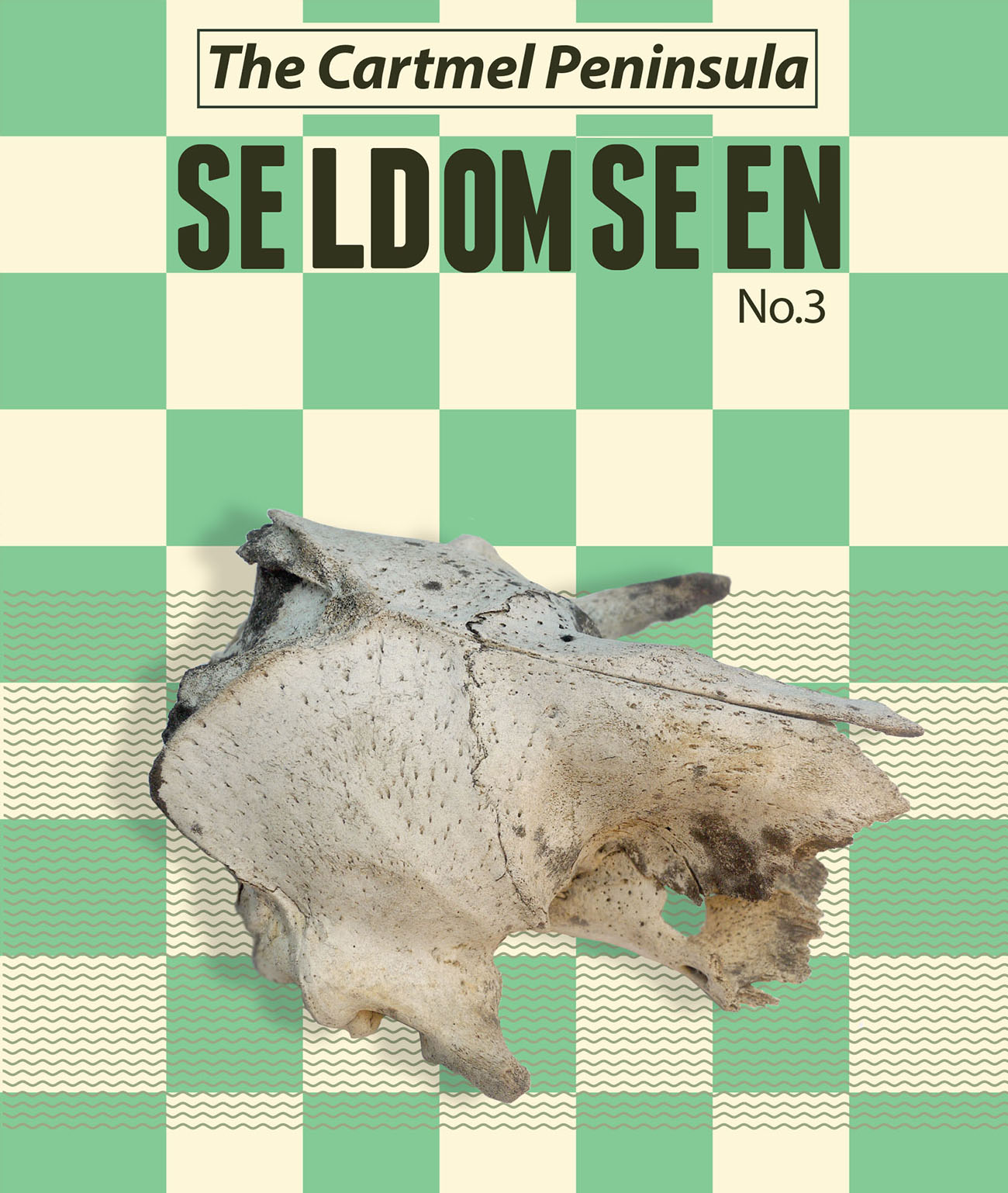
Cartmel Peninsula
Cartmel, Lindale, Witherslack, Haverthwaite, Backbarrow, Low Wood, Cark, Flookburgh, Grange-over-Sands, Newby Bridge & Bouth.
Featuring: The Oldest Northerner – Water Power – The White-faced Darter – Gunpowder – Holy Wells – ‘Iron Madness’ – Ancient Fisheries – Gun Butts – Sanatoriums – Limestone Pavements – Damsons – Ironworks – Fish Slabs – Viaducts – Mushroom Pill Boxes – The Last Wolf in England – National Nature Reserves – Graves with Skulls on & Pseudo-conglomerate rock…
“Industry has used the powerful flow of the River Leven at Backbarrow since medieval times, when Furness Abbey built its corn mills. In the early 18th C., a charcoal red ironworks was built (it operated until 1967, & is now a scheduled Ancient Monument). Subsequent Victorian cotton mills were built, & the closure of the Dolly Blue works, 1895-1981, saw the end of an era: although power does continue to be generated by the river”.Extract from the cover text of the Cartmel Peninsula map
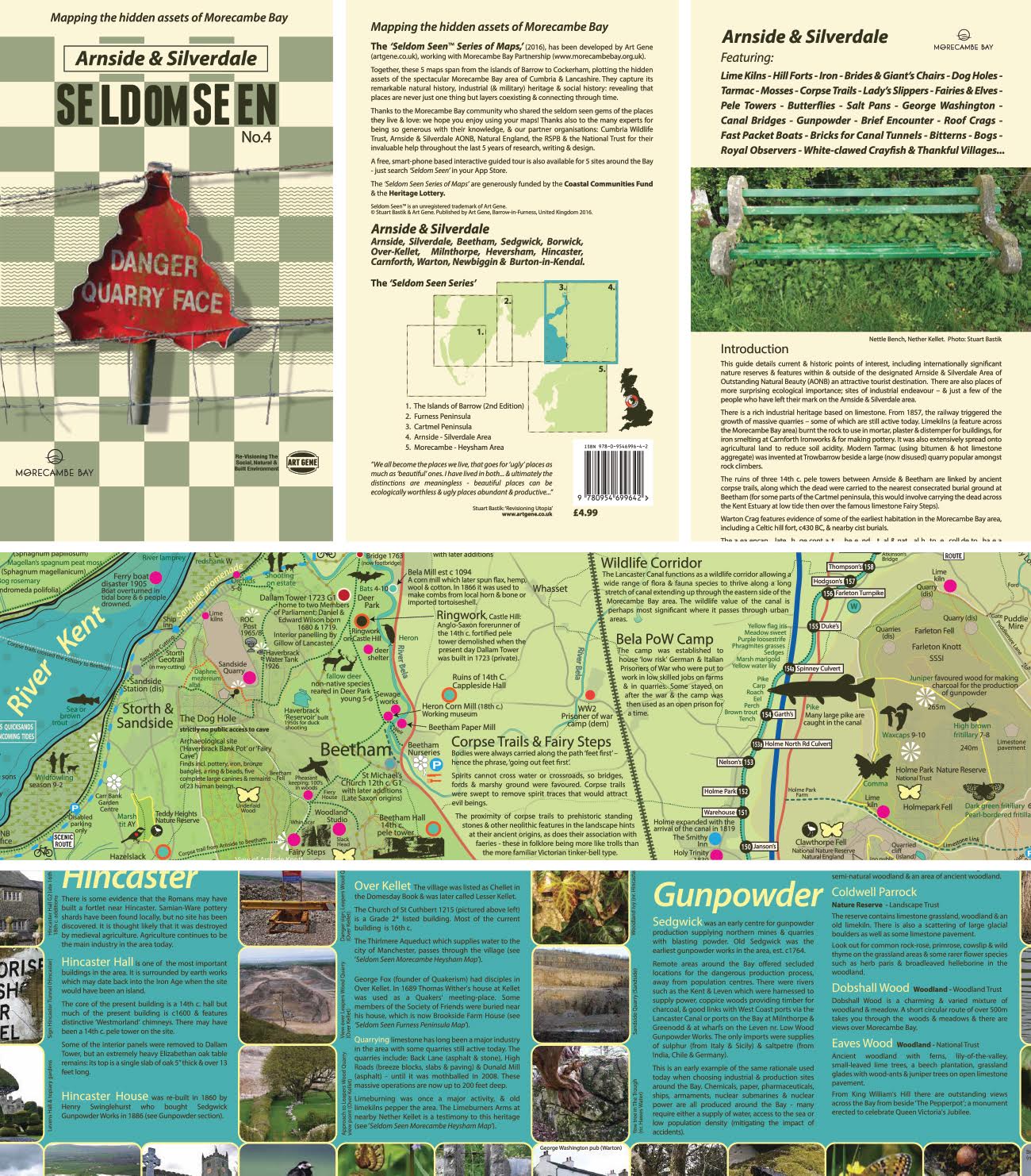
Arnside – Silverdale Area
Arnside, Silverdale, Beetham, Sedgewick, Borwick, Over-Kellet, Milnthorpe, Heversham, Hindcaster, Carnforth, Warton, Newbiggin, & Burton-in-Kendel.
Featuring: Lime Kilns – Hill Forts – Iron – Brides & Giant’s Chairs – Dog Holes – Tarmac – Mosses – Corpse Trails – Lady’s Slippers – Fairies & Elves – Pele Towers – Butter ies – Salt Pans – George Washington – Canal Bridges – Gunpowder – Brief Encounter – Roof Crags – Fast Packet Boats – Bricks for Canal Tunnels – Bitterns – Bogs – Royal Observers – White-clawed Cray sh & Thankful Villages…
“The ruins of three 14th c. pele towers between Arnside & Beetham are linked by ancient corpse trails, along which the dead were carried to the nearest consecrated burial ground at Beetham (for some parts of the Cartmel peninsula, this would involve carrying the dead across the Kent Estuary at low tide then over the famous limestone Fairy Steps)”.
Extract from the cover text of the Arnside & Siverdale map
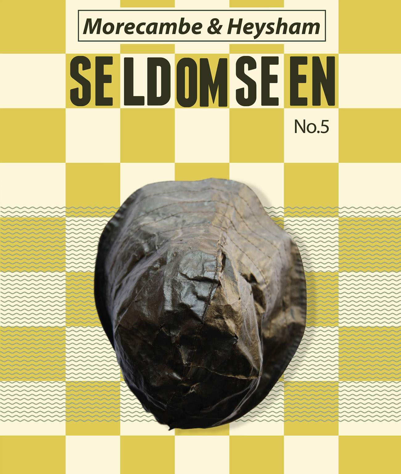
Morecambe – Heysham Area
Morecambe, Heysham, Lancaster, Hest Bank, Sunderland, Overton, Cockerham, Glasson, Conder Green, Forton, Quernmore & Claughton.
Featuring: Aqueducts – Sea Campion – Press Gangs – Carnivorous plants – Rock-cut Graves – Skylarks – Knot – Nuclear Power – Beaches – Belted Beauties – Whammels & Haafs – Romans & Slave Hats – The Entertainer – Baulks – Lumpsuckers – Peat Cutters – Porpoise – Linoleum – Lampreys – Samphire – Mission Churches – Quays – Castles – Clay Pits – Bradford Trams – Folly Towers & the Gallows…
“Heysham is best known today for its port & nuclear power stations, but the old village at Heysham Head is a relatively unexplored historic gem. St. Peter’s Church & St. Patrick’s Chapel, with its ancient rock hewn graves, c800 BC, are amongst the oldest ecclesiastical features in Lancashire”.Extract from the cover text of the Morecambe & Heysham map
The Seldom Seen™ Series of Maps are researched and designed by Stuart Bastik, director and co-founder of Art Gene, and are plumb full of the days spent backpacking and late nights of drawing which punctuated the years of research they took him to compile. Each of the 5 maps is the result of extensive consultation with hundreds of local residents and specialists through a participatory programme of road show events and expert-led guided walks, devised by Maddi Nicholson. You can discover our full programme of consultation events here.
Many thanks are due to the Morecambe Bay community who shared the seldom seen gems of the places they live and love. Thanks also for the invaluable support from partner organisations: Cumbria Wildlife Trust, Arnside & Silverdale AONB, Natural England, RSPB, The National Trust and Morecambe Bay Partnership.
Seldom Seen™ is an unregistered trademark of Art Gene. © Stuart Bastik & Art Gene. Published by Art Gene, Barrow-in-Furness, United Kingdom 2016.
All images, artwork and text on this website are protected by copyright and may not be downloaded or otherwise reproduced or distributed without the permission of Art Gene.
Seldom Seen – App
Seldom Seen – Series of Maps: Morecambe Bay
Seldom Seen – Introduction to Piel Island Visitor Centre Project
Seldom Seen – Collection
About Design Cafe and Seldom Seen Design Cafe
Seldom Seen – Furniture
Seldom Seen – Mapping Morecambe Bay
© Art Gene
www.art-gene.co.uk
enquiries@art-gene.co.uk
Tel: +44 (0)1229 825085
Art Gene
Bath Street,
Barrow-in-Furness,
Cumbria, LA14 5TY England, UK
All images, artwork and text on this website are protected by copyright and may not be downloaded or otherwise reproduced or distributed without the permission of Art Gene. © Art Gene associates, artists and partners, 2022.